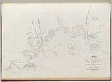
A plan of Port Macquarie including a sketch of part of Hastings River on the east coast of New South Wales.
Primary Artist
James Wallis (1785–1858)
Title
A plan of Port Macquarie including a sketch of part of Hastings River on the east coast of New South Wales.
Source
Wallis, James. An historical account of the colony of New South Wales and its dependent settlements. London: R. Ackermann, 1821.
Page or Plate number
plate 13
Reference
Ferguson (1941-69, 1986), 842
Date made
1821Place made
R. Ackermann, London, Greater London, England View on map Close map
Category
Print type
intaglio
Technique
engraving, printed in black ink, from one plate
Text printed from matrix
Printed lower right within image, 'A Plan / of / PORT MACQUARIE. / including a Sketch of Part / of / HASTINGS RIVER - / on the / EAST COAST / of / NEW SOUTH WALES.'
Matrix size
31.0 x 44.8 cm (printed image (irregular))
Edition information
print run unknown
Subject category
Australia, Art period: Colonial, New South Wales
Legacy id
145195
Creators
Preston, Walter. | (1787–1821) Australian | English | Male | engraver
Wallis, James. | (1785–1858) Australian | Irish | Male | artist
OXLEY, J. | Male | print after
Ackermann, Rudolph. | (1764–1834) English | Male | publisher
Last Updated
20 Nov 2025
Impressions
Collection
National Gallery of Australia | 2005.515.13
State
published state
Impression
undesignated impression as issued
view detailed information