A map of New South Wales, from the latest surveys.
Primary Artist
Title
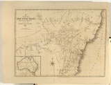
A map of New South Wales, from the latest surveys.
Source
Views in Australia or New South Wales and Van Diemen's Land Delineated. London: J. Souter, 1824
Reference
Ferguson (1941-69, 1986), 974;1031
Date made
1825Place made
London, Greater London, England View on map Close map
Category
Illustrated book
Print type
intaglio
Technique
engraving
Matrix size
33.0 x 22.5 cm (image)
Edition information
print run unknown
Subject categories
Australia, Book arts: Illustrated book | Map
Country of context
Australia
Legacy id
6779
Creators
TYRER, J | Australian | Male | artist
Last Updated
20 Nov 2025
Impressions
Collection
National Gallery of Australia | 84.125.2
State
published state
Impression
undesignated impression as issued
view detailed information