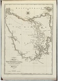
A new map of Van Diemens Land. From the best authorities. And from the most recent surveys.
Primary Artist
Title
A new map of Van Diemens Land. From the best authorities. And from the most recent surveys.
Source
Views in Australia or New South Wales and Van Diemen's Land Delineated. London: J. Souter, 1824
Reference
Ferguson (1941-69, 1986), 974;1031
Date made
1826Place made
London, Greater London, England View on map Close map
Category
Illustrated book
Print type
intaglio
Technique
engraving, printed in black ink, from one copper plate
Text printed from matrix
Printed lower left within image, 'A NEW / MAP of / VAN DIEMENS LAND, / FROM THE BEST AUTHORITIES / And the most recent / Surveys.' Printed lower centre below boarder line, 'Published [to be confirmed]. Printed lower right below boarder line, 'J. Tyrer, Sc.'. No date.
Matrix size
33.0 x 22.5 cm (image)
Edition information
print run unknown
Subject categories
Australia, Book arts: Illustrated book | Map
Country of context
Australia
Legacy id
34537
Creators
TYRER, J | Australian | Male | artist
Last Updated
20 Nov 2025
Impressions
Collection
National Gallery of Australia | 84.125.27
State
published state
Impression
undesignated impression as issued
view detailed information