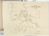
Map of the Leichhardt and Port Curtis districts.
Title
Map of the Leichhardt and Port Curtis districts.
Source
Transactions of the Philosophical Institute of Victoria, Vol.4, 1860
Page or Plate number
facing p.188
Reference
Ferguson (1941-69, 1986),
Date made
1859
Place made
Naam / Melbourne, Victoria, Australia View on map Close map
Category
Illustrated book
Print type
planographic
Technique
photo-lithograph, printed in black ink, from one stone
Support
white wove paper
State
published state
Impression
undesignated impression as issued
Edition information
print run unknown
Inscriptions or device by artist or designated agent
none
IRN
151987
Accession number
2011.1472.14
Accession method
Purchase
Meeting
Meeting 2, 2011/2012 (2011-10-25)
Provenance
Purchased by the National Gallery of Australia, from Peter Arnold Antiquarian Booksellers, Melbourne, 2011
Subject categories
Australia, Book arts: Illustrated book | Map
Last Updated
07 Jan 2013
