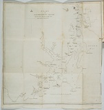
Chart of D'entrecasteaux Channel.
Title
Chart of D'entrecasteaux Channel.
Source
Ross, James. Hobart Town almanack and Van Diemen's Land annual Hobart: James Ross, 1836.
Page or Plate number
facing p.209
Reference
Ferguson (1941-69, 1986), 2174
Date made
1835
Place made
Nipaluna / Hobart, Tasmania, Australia View on map Close map
Category
Illustrated book
Print type
intaglio
Technique
engraving, printed in black ink, from one plate
Matrix size
43.0 x 41.6 cm (printed image)
Support
thin white wove paper
Support size
45.0 x 42.2 cm (sheet)
State
published state
Impression
undesignated impression as issued
Edition information
print run unknown
Subject description
Chart of D'entrecasteaux Channel which lies between Bruny Island and the south-east coast of Tasmania.
Collection
National Gallery of Australia
IRN
152087
Accession method
Transfer
Subject category
Australia, Book arts: Illustrated book
Last Updated
04 Jan 2013