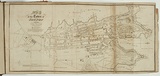
Map of the town of Sydney 1833.
Primary Artist
William Wilson (1795–1867)
Title
Map of the town of Sydney 1833.
Source
The New South Wales calendar and general post office directory. Sydney: Stephens & Stokes, 1834.
Page or Plate number
facing titlepage
Reference
Ferguson (1941-69, 1986),
Date made
1834
Place made
Warrane / Sydney, New South Wales, Australia View on map Close map
Category
Illustrated book
Print type
intaglio
Technique
engraving, printed in black ink, from one copper plate
Matrix size
18.0 x 39.2 cm (printed image)
Support
white wove paper
Support size
19.0 x 41.5 cm (sheet)
State
published state
Impression
undesignated impression as issued
Edition information
print run unknown
Inscriptions or device by artist or designated agent
Titled and dated printed, upper left within image in black ink 'MAP / of the Town of / SYDNEY / 1833.' Inscribed printed upper left within image in black ink 'Drawn & Engraved for / The NSW Gen.l Post Office Directors, / by permission of the Surveyor General.' Inscribed printed, lower left edge below image, in black ink,'Drawn at the Surv.r Gen.ls Office'.
Inscriptions or device by others involved in the works production
Printed, lower right edge within image in black ink,'W.Wilson Sculp.'
Collection
National Gallery of Australia
IRN
151702
Accession method
Transfer
Subject categories
Australia, Book arts: Illustrated book | Map
Creators
Wilson, William. | (1795–1867) Australian | British | Male | engraver
Stephens & Stokes. | (1831–) Australian | Organisation | printer
Last Updated
08 Jun 2026